
價格:免費
更新日期:2019-05-14
檔案大小:7.8M
目前版本:2.0.3
版本需求:Android 5.0 以上版本
官方網站:http://www.danubecc.org
Email:office@danubecc.org
聯絡地址:隱私權政策

A must have app for all the cyclists that plan to spend few days on the wheels riding long distances along the Danube. Based on the data European Cyclist Federation collected during EuroVelo 6 route assessment, this app will provide you with dozens of useful information either while you’re riding or planning your route.

Main features:
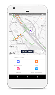
- GPS data for Danube Cycle Route – almost 3,000 km long part of EuroVelo 6 that follows the Danube from Black Forest until Black sea

- Let’s ride – riding mode in which the data is shown automatically while you’re riding, based on your location

- Route planner – planning mode where the data is shown based on selected starting point and chosen direction, ideal for getting quick overview what to expect on the road within following kilometres

- Help section – detailed description of all data categories and values, quite useful until you got used to our app icons

- Main / all data switch – choose whether you want only main or all data to be shown; main data is collected on 1km basis and it will provide you with crucial info such as road type and width, surface material and quality, riding direction, observed traffic congestion and speed limits for motorized traffic (in case you’re sharing the road). Other data is usually collected on 5km basis and includes 11 additional data categories
